
Google Maps for Trucks: What Works and What Doesn't
No, Google Maps doesn't have a true truck mode. It doesn't know your vehicle's height, weight or width, it ignores low bridges and environmental zones, and it almost always prefers the shortest car route. You can use Google Maps in a truck, but in professional operations you shouldn't rely on it. This article shows what's actually possible with Google Maps, where the limits are, and how to plan HGV-accurate, compliant routes.
Table of Contents
- Can you set Google Maps for trucks?
- Workarounds with Google Maps, and their limits
- Google Maps vs. real truck navigation
- We tested it: 10,000 real routes
- How much does a car route cost your truck?
- The truck-navigation alternative: IMPARGO
- Address accuracy: postcodes vs. full addresses vs. pins
- Keep dispatch and drivers on the same route
- Truck restrictions & vehicle profiles
- Why this protects your margins
- FAQ
Can you set Google Maps for trucks?
In short: no. Google Maps offers driving, two-wheeler, walking and public-transport modes, but no truck or commercial-vehicle mode. You can't enter a vehicle height, gross weight or axle count for the route to respect.
The only movement in that direction: in 2025 Google began rolling out "trailer-friendly routes" for a few specific US vehicle models via Android Automotive. That's not a general truck mode, it doesn't apply in Europe, and it doesn't help day-to-day in a haulage operation. For European road freight, Google Maps remains a car navigation app.
Workarounds with Google Maps, and their limits
Drivers who use Google Maps in a truck anyway tend to rely on these methods. They make the trip a little safer, but they don't replace truck navigation:
- Prefer motorways and toll roads: route options can partly avoid minor roads, but Google never checks bridge heights or weight limits.
- Add waypoints on main roads: roughly forces a safer corridor, but it's manual work on every trip and easy to get wrong.
- Keep height and weight in your head: only works while the driver knows every critical bridge, no reliable basis on new routes.
- "Google Maps for trucks free": Google Maps is free, but no setting unlocks the missing truck features. A free app without a vehicle profile is still a car app.
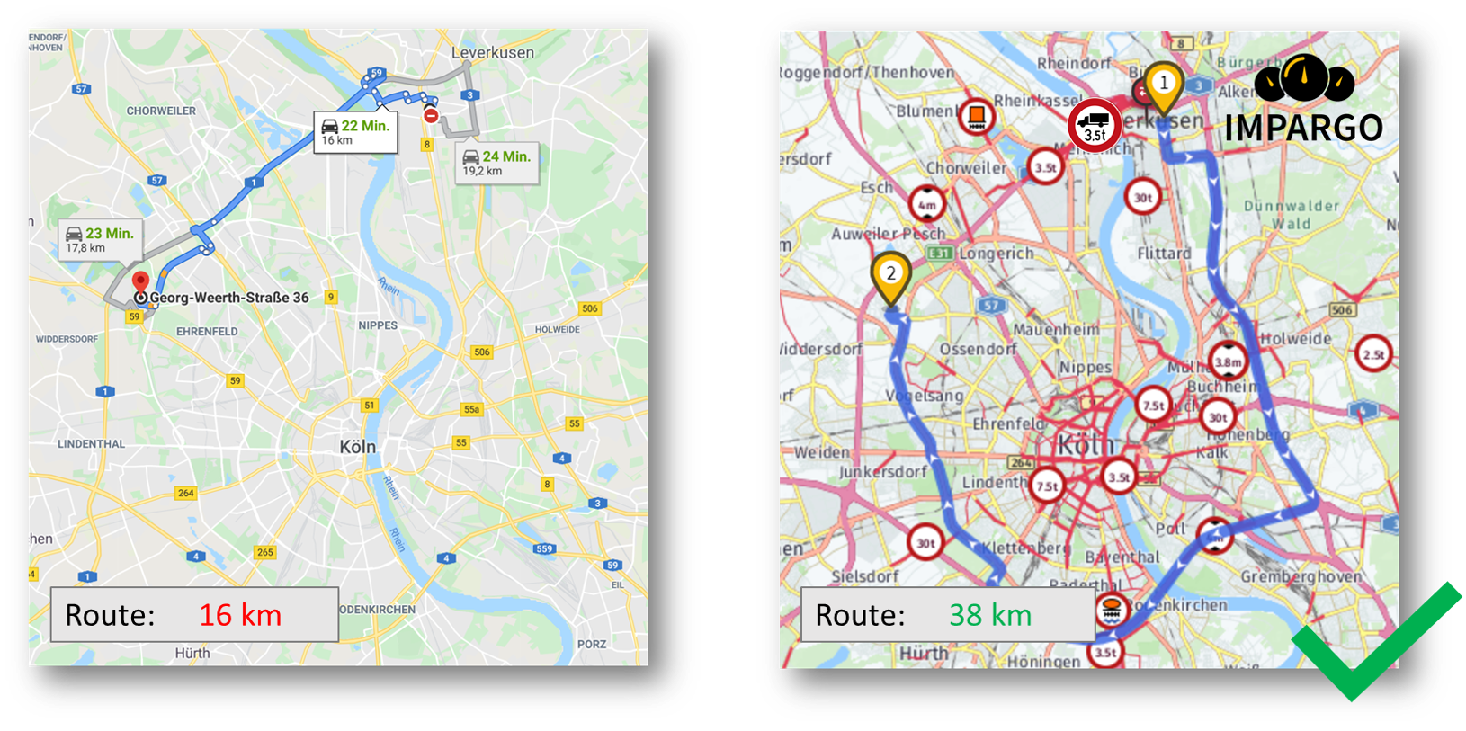
The core problem remains: Google Maps doesn't know you're driving a truck. The moment a route recalculates, it falls back to the shortest car path.
Google Maps vs. real truck navigation
Both tools have their place, just for different vehicles. The honest comparison:
We tested it: 10,000 real truck routes
The points above are easy to assert. So we measured them. We compared 10,000 real 40-tonne routes across Europe: the IMPARGO truck-legal route against the Google Maps car route for the exact same start and end points. 9,999 produced a valid comparison. Here is what the data showed.
Time: slower on almost every route
By time, the gap is the rule, not the exception. 95.5% of routes were slower by truck than Google's car estimate. The median route took +21% longer (mean +25%), the 90th percentile +31%, and the 95th +39%.
This is not tail risk, it is the default. Every ETA built on a car estimate is quietly optimistic, usually by about a fifth, before you hit a single restriction.
Distance: usually fine, until it isn't
By distance, the car figure is a decent guide most of the time: the median difference was just +0.25%. But the tail is brutal. The 90th percentile was +8.7%, the 95th +22.3% (that is 1 route in 20), and the worst 1% ran +155% or more, when a weight limit, low bridge or truck ban forces a long detour Google cannot see.
Car distance is fine on average, until the one route where it is catastrophically wrong, and that is the route that blows up a day's schedule.
Method: 10,000 randomly sampled 40t routes (IMPARGO, fastest mode, no traffic, no via points, over 500 m), each compared to the Google Maps car route for the same origin and destination. 9,999 valid comparisons; one no-route case excluded.
Usually close on distance, almost always wrong on time, occasionally wrong on both. That gap is money. See what it costs on one of your own routes below.
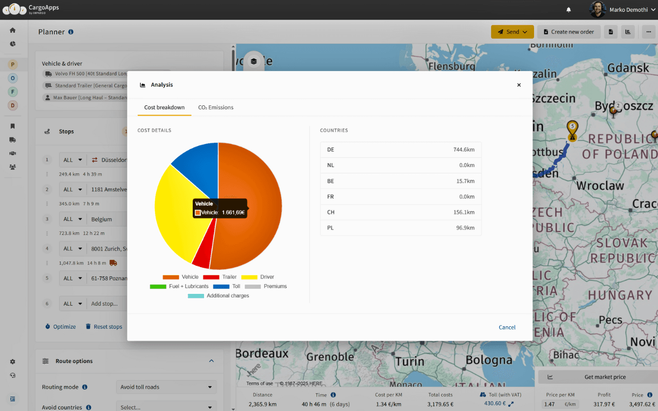
How much does a car route cost your truck?
An HGV-compliant route is almost always longer than the shortest car path Google Maps shows, because it routes around bridges, closures and zones. Quote with car kilometres and you give away money on every trip.
Run it with your own figures:
Don't like the number you're seeing? That gap is exactly what truck-accurate planning removes:
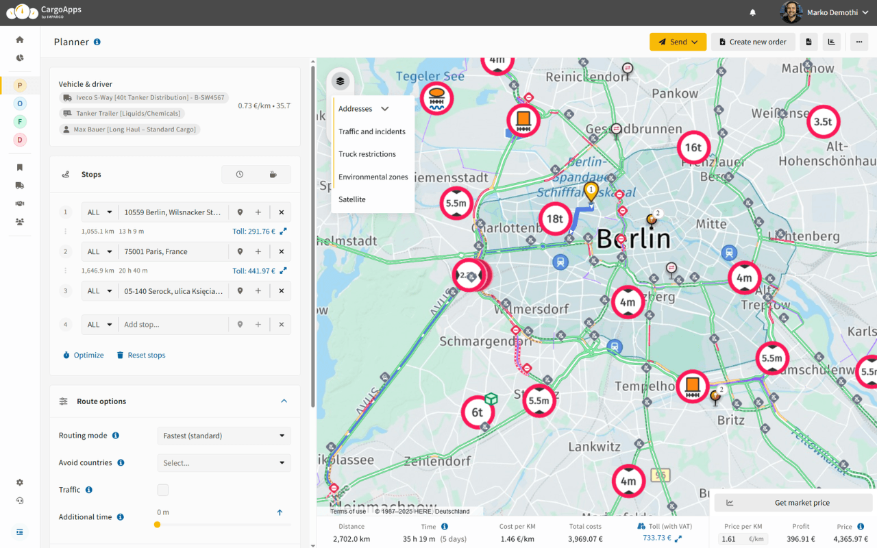
The truck-navigation alternative: IMPARGO
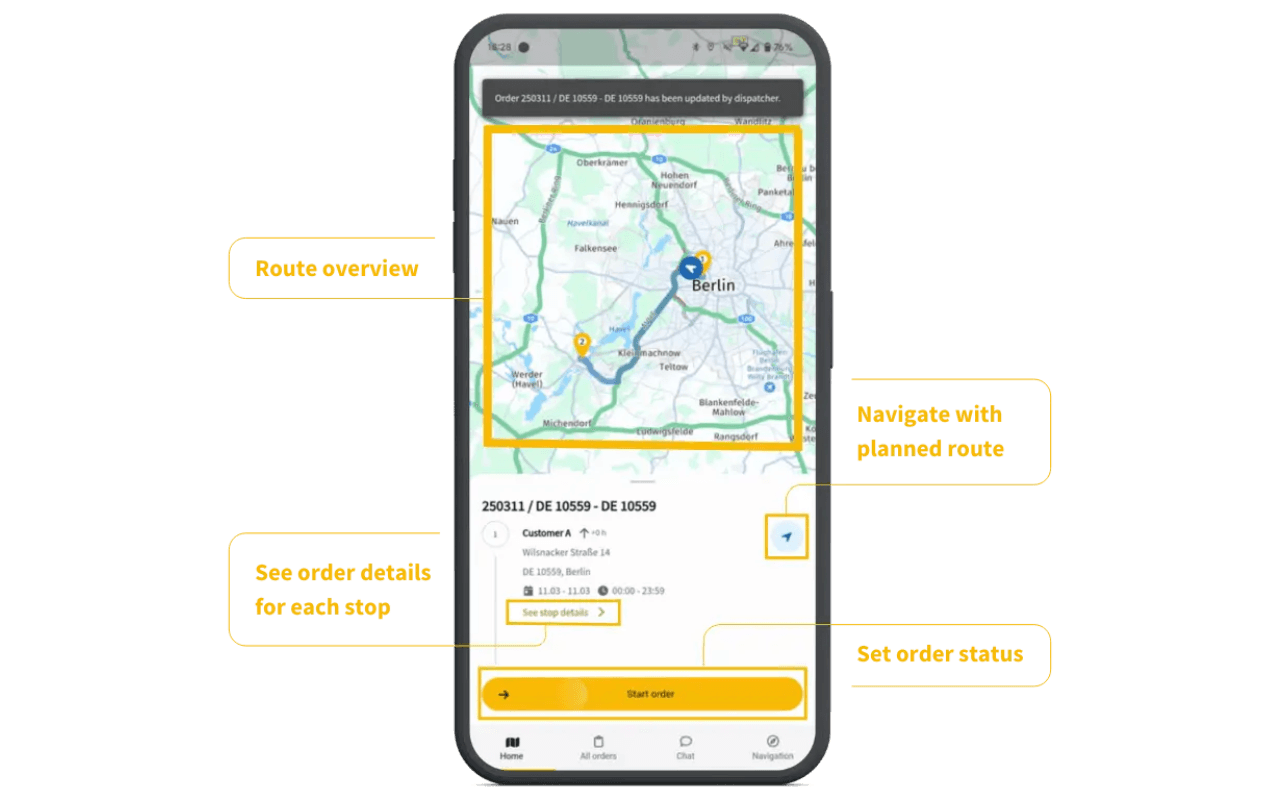
IMPARGO Navigation for Trucks is built for European road freight. It delivers accurate, compliant turn-by-turn truck navigation via the DriverApp and keeps dispatch and drivers aligned by syncing the tours planned in the Planner Module. In effect it is the truck route planner and HGV sat nav that Google Maps cannot be.
- Prefers A/B-road approaches; uses smaller roads only for the last mile
- Applies vehicle attributes (weight, height, length) and HGV restrictions including LEZs
- Live traffic with dynamic rerouting when conditions change
- Planner Module → DriverApp sync so drivers follow the route you planned
For when a TMS is worth more than free navigation, see also: Why you should use a TMS for trucks instead of Google Maps. For a step-by-step guide to route planning, see How to plan a truck route in IMPARGO.
Address accuracy: postcodes vs. full addresses vs. pins
Rural postcodes often span kilometres. Postcode-only gets you "nearby", not at the correct gate.
- Enter full addresses (or postcode + house name/number)
- Drop precise entrance pins (GPS or what3words) for gates and bays
- Add an A-road waypoint to lock in a safe approach
- Share approach notes (e.g., "enter via north gate; avoid village lane")
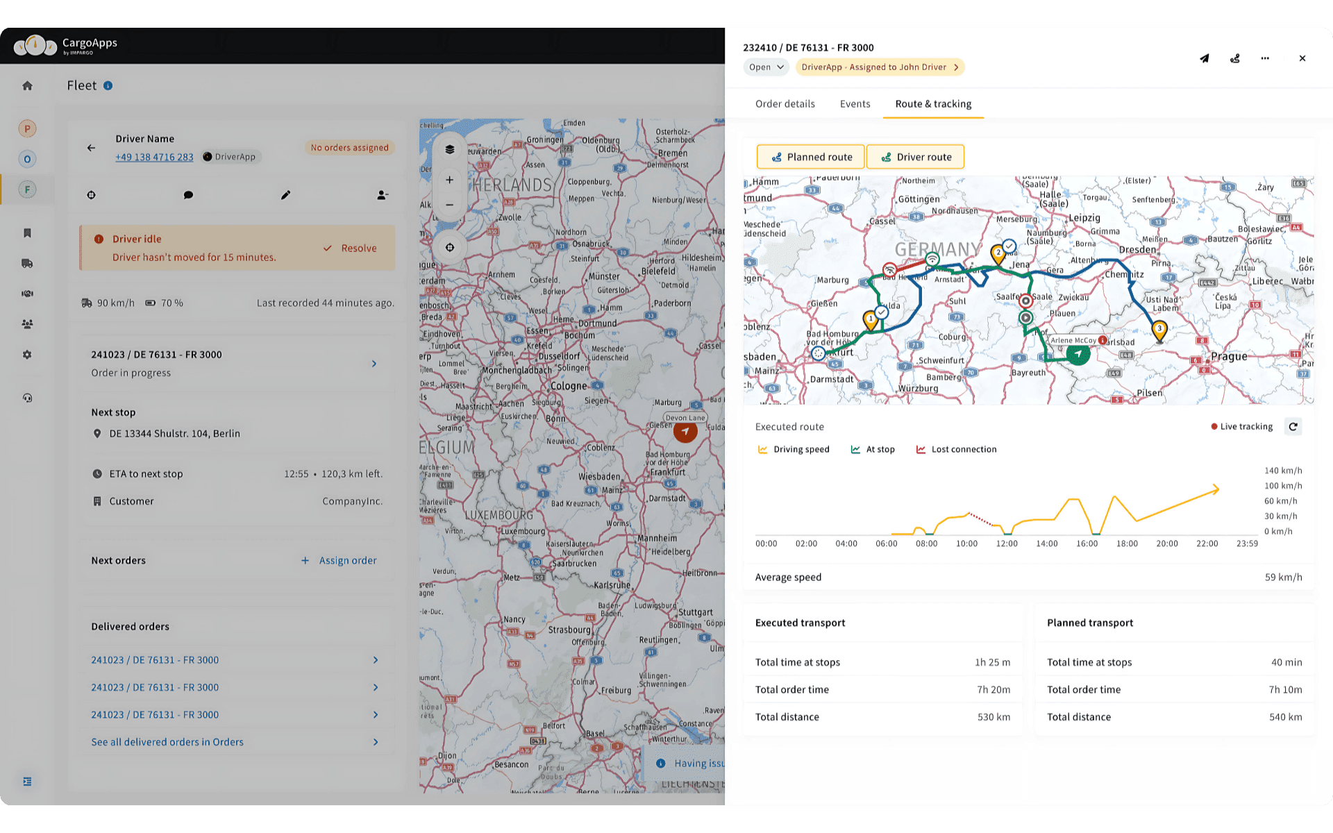
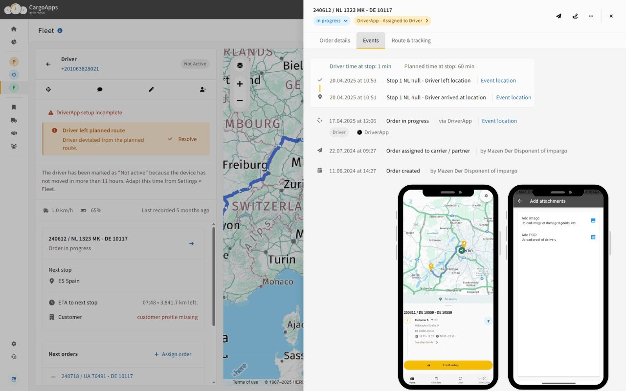
Keep dispatch and drivers on the same route
Car apps improvise; IMPARGO keeps everyone on plan. The tour planned in dispatch is exactly the one the driver drives.
- Dispatcher-planned tours sync instantly to the DriverApp
- One-tap start with truck-compliant guidance
- Auto-reroute if a driver leaves the assigned path
- Mark stops, share live location and order updates
- Digital delivery confirmation and optional off-route alerts
Truck restrictions & vehicle profiles
IMPARGO applies vehicle-specific rules on every journey across Europe so you stay compliant:
- Weight, height, length, axles
- Road and bridge limits
- Environmental / LEZ zones
Why this protects your margins
Every wrong route costs in several places at once:
- Fuel burned on detours
- Driving time (and legal hours) lost on unsuitable roads
- Late arrivals and missed slots
- Damage risk from narrow lanes and overhanging branches
- Fines for accidental violations
Quoting with car distances underprices jobs. Use truck-accurate kilometres and toll-aware routing to protect the revenue per trip your business needs.
FAQ
Can you set Google Maps to a truck mode?
No. Google Maps has no truck or commercial-vehicle mode and no way to enter height, weight or axle count. There's no setting that makes the app respect truck restrictions.
Is there a free Google Maps for trucks?
Google Maps itself is free, but it has no truck features. A free app without a vehicle profile stays a car navigation app. For HGV-compliant routes you need a purpose-built tool such as the IMPARGO DriverApp.
Does Google Maps account for low bridges and weight limits?
Not reliably. Because Google Maps doesn't know your vehicle, it can route trucks under low bridges or onto weight-limited roads. Bridge and tonnage limits aren't systematically built into the route.
What truck navigation is better than Google Maps?
Any navigation with a real vehicle profile and Europe-wide truck restrictions. IMPARGO links planning in the Planner Module with turn-by-turn guidance in the DriverApp, so the driver follows exactly the route dispatch planned.