The truck navigation feature in the IMPARGO DriverApp provides precise, truck-specific routing using the recommended IMPARGO Navigation system. It ensures efficient and safe transport operations by allowing drivers to start navigation directly from the app, view transport updates, and manage key settings like offline maps and vehicle profiles.
IMPARGO Knowledge Center
Unleash the full potential of our software with our comprehensive Knowledge Center, offering detailed information on its functionality and features.
Navigate with The DriverApp
The IMPARGO DriverApp Navigation is designed to follow the dispatcher’s planned route as closely as possible, while still allowing for dynamic adaptation when necessary. The routing behavior depends on whether the route includes via-points (intermediate stops) or not. [Read: Plan Truck Routes: Change Route via Drag & Drop]
Routing Without Via-Points:
The navigation system will continue to follow the originally planned route as long as the vehicle remains within 500 meters of it.
If the driver deviates less than 500 meters, the system will not generate a new route. Instead, it will attempt to guide the driver back to the original route.
If the driver deviates more than 500 meters, the system will automatically recalculate a new route to the next defined stop (e.g. the delivery or pickup location).
Important: If the vehicle later returns within 500 meters of the original route, the system does not switch back to that route. To return to the original planned route, the driver must either:
- Manually restart the navigation, or
- Deviate again from the recalculated route to trigger a new recalculation.
Routing With Via-Points:
Via-points are used only during the initial route calculation to influence the route shape (e.g. for detours or specific roads).
If the driver deviates more than 500 meters from the planned route:
- The system will ignore the via-points during recalculation.
- A new route is generated directly to the next stop, bypassing all previously defined via-points.
The navigation does not track the status of via-points (i.e., whether they were reached or passed).
Important: Similar to routing without via-points, if the vehicle later returns within 500 meters of the original route, the system does not revert back to it automatically. A return to the original route requires:
- A manual restart of navigation, or
- Another significant deviation from the recalculated route.
IMPARGO DriverApp vs. Other Navigation Apps
In contrast to general-purpose navigation apps, IMPARGO Truck Navigation is designed to prioritize adherence to dispatcher-defined routes. Standard apps typically ignore pre-planned routes and continuously recalculate based on the current position. IMPARGO, on the other hand, maintains the dispatcher’s intended routing unless significant deviations occur, helping ensure that logistics plans are followed more accurately.
IMPARGO recommends using its own navigation system for truck-appropriate routing and optimal performance. The DriverApp navigation will follow the planned route from the dispatcher, provided the driver does not deviate more than 500 meters from the route.
From the Home Screen of the DriverApp, you can start navigation to the next stop of your current order by clicking the blue arrow button. You’ll be prompted to choose from your installed navigation apps.
Steps to Start Navigation:
Step 1: Navigate to the Home Screen.
Make sure you're viewing the current order.
Step 2: Tap the Navigation Button.
Click the blue arrow to initiate navigation.
Step 3: Select a Navigation App.
Choose from your installed apps. For best (most accurate) results, use IMPARGO Navigation.
The DriverApp supports multiple truck and non-truck navigation systems, allowing flexibility for different driver preferences and devices.
Supported Truck Navigation Apps:
- IMPARGO Navigation
- TomTom GO (Truck version)
- TomTom GO Fleet
- Sygic
Supported General Navigation Apps:
- Google Maps
- Apple Maps
- Baidu Maps
- Amap (Gaode Maps)
- Waze
- Yandex Maps
- Yandex Navigator
- Citymapper
- Maps.me
- OsmAnd / OsmAnd+ (Android)
- 2GIS
- Tencent (QQ Maps)
- Here WeGo
- Petal Maps (Android)
Access the settings menu from the Home Screen by tapping the gear icon in the top right corner. Here, you can configure key features for truck navigation, including offline maps, default navigation apps, and vehicle profiles.
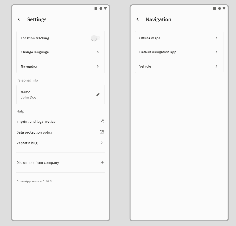
Steps to Configure Settings:
Step 1: Open Settings.
Tap the gear icon on the Home Screen.
Step 2: Manage Offline Maps (Coming Soon).
Download maps for specific countries or regions for offline use.
Step 3: Set Default Navigation App.
Choose your preferred navigation tool to use by default.
Step 4: Create Vehicle Profiles.
Add truck-specific details like:
- Number of axles
- Gross vehicle weight
- CO₂ emissions class
Vehicle profiles sent by dispatchers are stored in the DriverApp and can be edited by the driver if needed, ensuring routes are always aligned with vehicle restrictions.
Need help? Contact our support team.
The free navigation can be accessed via the navigation tab at the bottom right. Here, you can choose from parking, fuel stations, restaurants, and more. You can also enter an address manually for routing. After selecting an address, the route options will be provided, and you can start the navigation. During navigation, arrival time, time to arrival, and distance to the destination are displayed. Voice prompts can be deactivated by clicking the speaker icon. Speed limits and the current routing profile are also shown.
Here's how to start free navigation for truck drivers:
Step 1: Access free navigation.
Go to the navigation tab located at the bottom right of the screen.
Step 2: Select destination type.
Choose from options like parking, fuel stations, restaurants, etc., or enter an address manually.
Step 3: Enter address.
Input the desired address for routing.
Step 4: Select route.
Review the suggested routes and select one to start navigation.
Step 5: Start navigation.
Begin navigation and monitor the provided information (arrival time, distance, etc.).
© IMPARGO 2026, All rights reserved.